Shin-Sakuranomiya Bridge
Osaka (Kita and Miyakojima wards)
Sources checked October 2026
- Year
- 2006
- Architect
- Tadao Ando
- Type
- Steel arch road bridge
- Access
- In service on National Route 1, with pavements open to pedestrians (Osaka National Highway Office, October 2026)
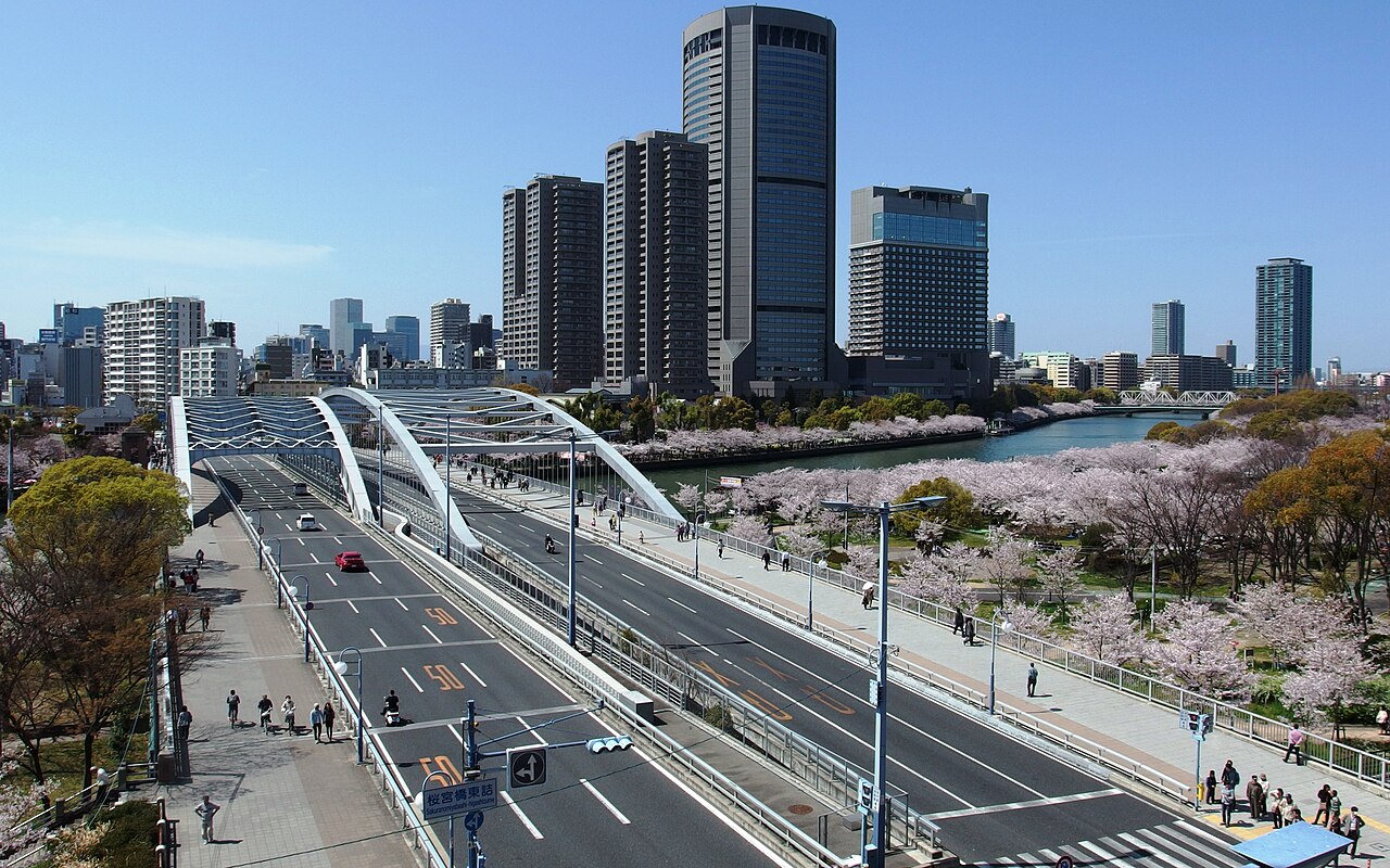
In Osaka, this National Route 1 bridge stands beside the Sakuranomiya Bridge of 1930, nicknamed "Ginbashi", the silver bridge. Tadao Ando, a member of the committee that settled its design, wrote the concept: a steel arch matching the old one in height and axis but more slender, so that the two bridges form a pair. Opened to traffic in December 2006, it carries the eastbound lanes and the old bridge the westbound ones.
Affiliate links — booking through Verrière helps fund our research, at no extra cost to you.
History
The Shin-Sakuranomiya Bridge (新桜宮橋) stands beside a bridge of 1930, the Sakuranomiya Bridge (桜宮橋), known as "Ginbashi" (銀橋), the "silver bridge", because of its colour. Designed by Takeda Goichi (武田五一), the old bridge crosses the Ōkawa (大川), the former course of the Yodo, on National Route 1, between Tenmabashi in Kita ward and Nakano-chō in Miyakojima ward. The new bridge came from the widening of that road, from 22 m and four lanes to 40 m and six lanes. It was built upstream, to the north, and the old bridge was kept: the new one carries the eastbound traffic, the old one the westbound, three lanes each.
The design was settled in 2000 by a committee of experts, which met three times between August and November, and of which Tadao Ando was a member. Residents had been asked for their views: three quarters favoured an arch bridge. The committee compared the types: the girder bridge, hard to justify for crossing the Ōkawa without a pier and markedly more expensive, was set aside, as was the cable-stayed bridge, whose tower would have looked alien beside the old one. That left two arches: one as close as possible to the old bridge, the other a new form that keeps the old bridge's image while showing technical progress. The first would have needed a stiffening girder rising about 2.5 m above the road surface, and about three times as much steel; the committee chose the second, on which Ando explained that the two bridges side by side would show the difference in technique between their two periods.
The foundations were built from July 2002 to March 2004, the superstructure from October 2003 to March 2006. The new bridge opened to traffic in December 2006; the whole 0.7 km widened section was completed in March 2009.
Architecture
The bridge is a steel arch tied to a stiffening girder by hangers. Ando's concept makes it close to the old bridge in height and axis, but built with the most recent materials and methods, and therefore much more slender. Standing side by side, the two bridges are meant to make the gap in technique between the two building campaigns, and the time between them, felt, and the new one is to bring out the old.
To make the two bridges agree, the new arch has the same height as the old one, and the depth of both the arch rib and the stiffening girder is kept as small as possible. The hangers are thin, so that the old bridge stays visible through the new one: they are high-strength cables 75 mm in diameter. The ratio of the arch's height to its length is 1/10.5, against 1/6.9 for the old bridge; the superstructure weighs 17 t per metre, against 22 t.
This slenderness called for high-grade steel in very thick plates, up to 82 mm, which cannot be bolted: all the sections of the main structure are welded on site, a first in Japan for an arch bridge of this type. Windbreaks surrounded the welds during construction. The arch is longer than that of 1930 because, for flood safety, the piers of the new bridge have to be farther apart.
Use today
The bridge carries National Route 1 eastbound, the old bridge carrying it westbound. The old bridge is listed in the civil engineering heritage of the Japan Society of Civil Engineers.
The widening works gave pedestrians wider pavements, which lead to the cherry trees of the Osaka Mint, to a building listed as an Important Cultural Property (泉布観), and to the Tenjin festival (天神祭). Both bridges are very busy in the season of that festival and in that of the cherry blossom.
Visiting
The bridge is part of National Route 1 and is crossed on foot by the pavements. Sakuranomiya Park (桜之宮公園) runs along the Ōkawa nearby. Allow about twelve minutes' walk from JR Osakatemmangu Station or from Temmabashi Station on the Tanimachi metro line.
34.70° N, 135.52° E
Greenhouses nearby
Architecture nearby
Sources (12)
- kkr.mlit.go.jp/osaka/works/dourokanri/ginbashi/
- kkr.mlit.go.jp/osaka/works/dourokanri/ginbashi/concept/
- kkr.mlit.go.jp/osaka/works/dourokanri/ginbashi/koji_keikaku/
- kkr.mlit.go.jp/osaka/works/dourokanri/ginbashi/koji_summary/
- kkr.mlit.go.jp/osaka/works/dourokanri/ginbashi/about/
- kkr.mlit.go.jp/osaka/works/dourokanri/ginbashi/design_02/
- kkr.mlit.go.jp/osaka/works/dourokanri/ginbashi/design_03/
- kkr.mlit.go.jp/osaka/press/2022/86_221007_2.pdf
- kkr.mlit.go.jp/osaka/katsudou/2016/170304.pdf
- www-1.kkr.mlit.go.jp/plan/ippan/zigyohyoka/ol9a8v000000dfxl-att/12.pdf
- osaka-info.jp/experience/ja/osaka/spot/251
- api.openstreetmap.org/api/0.6/way/442214399
Affiliate links — booking through Verrière helps fund our research, at no extra cost to you.